

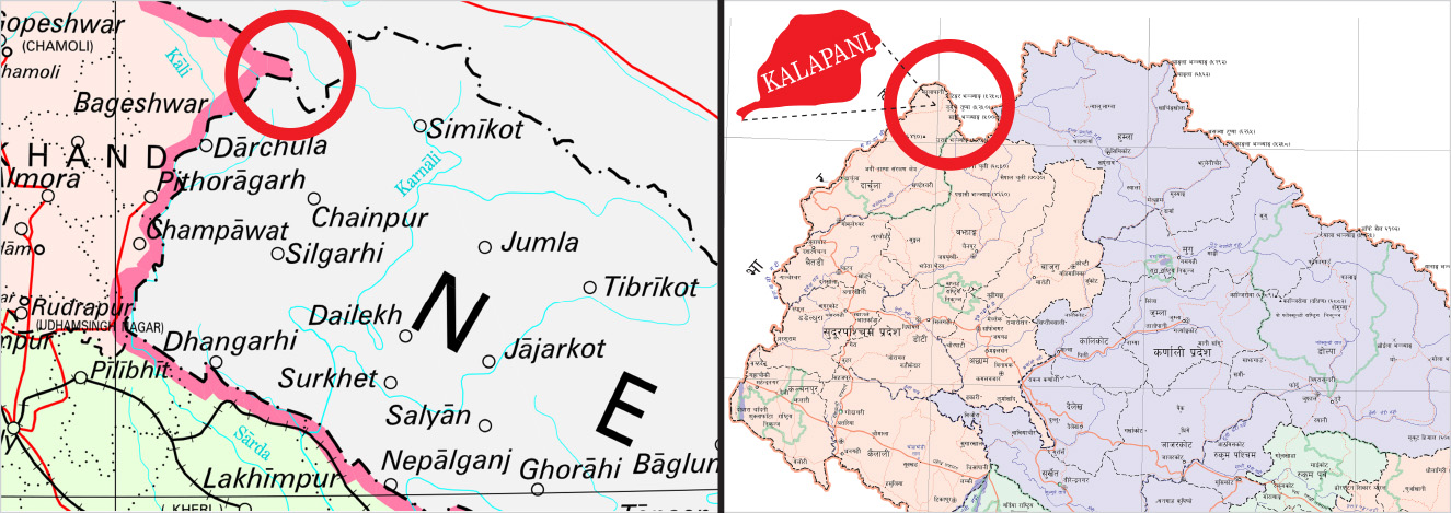
Kathmandu: The Survey Department has taken issue with a new Indian political map that places the disputed territory of Kalapani within its territory, a scenario Nepali officials described as the “status quo”.
The Indian Ministry of Home Affairs on Sunday released a new political map after India formally split up the disputed Jammu and Kashmir state into two federal territories, in line with an August move by the Narendra Modi government to rescind Kashmir’s autonomy.
“Our technicians and officials have examined the new Indian political map,” said Prakash Joshi, director-general of the Survey Department. He, however, refused to share details because he had to “communicate the matter with higher authorities first.”
“I will brief the higher authorities, including the foreign secretary and my senior officials at the ministry first,” Joshi told the Post. “I cannot share the findings right now with the media.”
Survey Department officials, who did not wish to be named, told the Post that disputed tracts of land between Nepal and India, like Kalapani and Lipu Lekh, are placed inside Indian territory.
If Nepal has any objection to the new political map of India, it is the job of the Ministry of Foreign Affairs to communicate with New Delhi through diplomatic channels, the officials said.
Nepal has long been claiming that Kalapani, Lipu Lekh and Limphuyadhara are very much part of its territory. The Survey Department has even produced maps of Nepal that show all three disputed pieces of land as a part of Nepal.
“The Survey Department has prepared a map of Nepal that includes Kalapani as a part of Nepal and has urged all government and private offices to use the official map of Nepal released by the department,” said Ganesh Bhatta, former director-general of the department.
As Nepal has always included Kalapani within its territory and India within its, the piece of land has remained a matter of dispute, said Bhatta.
Nepal, however, has had opportunities at least on two occasions in the past to sort out its border issues with India.
When China and India reached an agreement to build bilateral trade corridors through Lipu Lekh via the Indian state of Uttarakhand in 2015, Nepal had taken up the issue with both countries.
The then government had written to both New Delhi and Beijing about the agreement, but “we never received satisfactory responses,” government officials had told the Post in 2017.
Again in 2017, foreign relations analysts had told the Post that the Doklam standoff between India and China could be a good opportunity for Nepal to raise the border issue with New Delhi. That opportunity, however, was missed.
Over the past two years, there has not been much communication between Kathmandu and New Delhi regarding disputed territories like Kalapani, even though officials from both sides have agreed to sort out border issues.
The Kalapani dispute began in 1962 after India withdrew all its border outposts from the northern belt of Nepal, according to Buddhi Narayan Shrestha, former director-general of the Survey Department.
Although claimed by Nepal, Kalapani has been occupied by India’s security forces since the 1962 war with China.
During Matrika Prasad Koirala’s prime ministership in 1952, Nepal allowed India to station its troops in Kathmandu and on Nepal’s northern border, including Kalapani. India later withdrew from all other posts and stationed its troops on its side of the border of Kalapani. But later, India moved into Nepali territory, making Kalapani a disputed area between Nepal and India, according to Shrestha.
During the third meeting of Nepal-India Joint Commission in Kathmandu in 2014, both sides had agreed to assign the task of resolving the boundary dispute in Kalapani and Susta to the Foreign Secretaries of Nepal and India, but there has been no major development so far.
However, Nepal and India have prepared 182 sheets of boundary maps, besides Kalapani and Susta, and as per the agreed boundary maps, Nepal and India have begun the demarcation of the border, which is likely to be completed in 2022.
During the Fifth Meeting of the Nepal-India Joint Commission in Kathmandu on August 21 and 22, the foreign ministers of both countries had directed a foreign secretary-level mechanism to prioritise work on the outstanding boundary issues with technical input from the Boundary Working Group. Nepal and India had formed the working group at the Surveyor General level to settle all boundary issues.
The dispute over Lipu Lekh emerged after India and China agreed to build a bilateral trade corridor through Lipu Lekh in 2014, contesting Nepal’s claim. Nepal has been opposing the bilateral agreement between India and China on Lipu Lekh on the grounds that it is against the provisions of the 1816 Sugauli Treaty signed between Nepal and India.
Addressing the International Relations Committee of House of Representatives on February 10, Foreign Minister Pradeep Gyawali had said that India and China could not discuss the matter or make it a bilateral trading route without the presence of Nepal.“We do not accept Lipu Lekh as a tri-junction between Nepal, India and China,” Gyawali had told the House committee. “It will only be finalised after Nepal and India complete final demarcations. No country can discuss Nepal’s territory in our absence.”
(Source: Anil Giri, The Kathmandu Post)